The Arapaho are an Algonquian-speaking group; therefore from a greater language group that also includes the Cree, Blackfoot, Ojibwa, Chippewa, Cheyenne, and Gros Ventre tribes (Lowie 1954). The Arapaho have been recorded as having five divisions within their tribe: the Hit‘un’nno (The Begging People), Baasa w’ une‘nno (The Big Lodge People or Shelter Man), Hinan ‘ina (The Blood Pudding, Red Willow, and Sage People), H’anaxaw’ne’na (The Rock Men), and N’wacinaha‘ana (The South People). The first three have been documented as having closely related dialects, while the latter two have a dialect that is divergent from the rest of the tribe (Fowler 2001). It is believed that the Hit‘u-n’nno people became the Gros Ventre, who distinguished themselves from the Arapaho and moved northward. The two tribes speak mutually intelligible dialects (Kroeber 1983[1902]:6). The Cheyenne, with whom the Arapaho maintain close ties, have distinct differences in dialect, the Arapaho having one of the most specialized dialects of any Algonquian-speaking Great Plains group (Kroeber 1983[1902]).
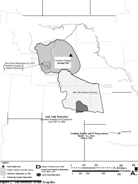
It is believed that the Arapaho people abandoned a sedentary agricultural lifestyle in Minnesota and North Dakota for a more nomadic lifestyle. They are recorded as migrating westward into the Plains region, and to what is now eastern Wyoming and Kansas, before the eighteenth century (Hall 2001) (Figure 2). According to traditional accounts, the Arapaho lived in villages and raised corn crops before they began to migrate. As Hall (2001) documented from the accounts of Jean Baptiste Trudeau, a French explorer, the Arapaho were continually migrating west and south from Canada to southeastern Montana and eastern Wyoming. It was later documented around 1820 that the Arapaho made alliances with the Cheyenne and were fighting the Kiowa, Comanche, and Sioux for resources located within the Great Plains region (Hall 2001).
 Prior to acquiring horses, the Arapaho used domesticated dogs for both food and travel and were referred to as the Arapaho, a Crow term meaning “many tattoo marks,” a term also used by the Arikara, Mandan, and Hidatsa (with whom they traded) to describe the small tattoo marks placed on their bodies (Fowler 2001; Hall 2001). With horses in prominence among the Arapaho by 1800, Truteau (1912) documented that the Arapaho were living between the Yellowstone and Platte rivers and trading horses and prairie turnip flour to the Arikara for corn. By that time, the Cheyenne and Arapaho were recorded as wintering together in Arapaho territory, possibly near the foot of the Rocky Mountains in Wyoming and Colorado and separating in the spring, as the Cheyenne migrated toward the Missouri River villages for trade (Coues 1897). Though linguistically related, the Cheyenne and Arapaho are considered two culturally distinct groups. However, both tribes have been suggested as being so intertwined that they are documented as emerging into the Plains region at the same time, and have been located in the same general vicinity. Intermarriage, trade, and co-habitation during winter months were common between the two tribes (Fowler 2001).
During the mid-1800s, Plains tribes struggled against one another to gain access to resources located along the waterways of northeastern Wyoming and the Black Hills. After being successfully pushed south of the North Platte River by the Sioux and Crow, the Arapaho and Cheyenne worked together to push the Comanche and Kiowa out of northeastern Colorado and south of the Arkansas River (UW 2003). Meanwhile, as a result of the Fort Laramie Treaty of 1851, European settlers began to occupy new territories in the west. By that time, the Arapaho began to divide into two separate groups: Northern and Southern Arapaho. According to the Arapaho, most of the H’anaxaw’ne’na and N’wacinaha’ana people became known as the Southern Arapaho and the Baasa w‘une‘nno, Hinana‘ina, and some of the H’anaxaw’ne’na and N’ wacinaha‘ana people became the Northern Arapaho (Fowler 2001). The Northern Arapaho began to settle territories north of the Platte River in Wyoming and in the Big Horn Mountain region in Montana, while the Southern Arapaho moved further east and south of the Rockies, relocating near the headwaters of the South Platte and along the tributaries of the Arkansas River (UW 2003). The Fort Laramie Treaty of 1851 also maintained territories for the Arapaho, 300 miles east into Kansas and Nebraska (UW 2003). Although these lands were to be shared with the Cheyenne, the Arapaho concentrated their habitations westward to the edge of the Rocky Mountain foothills and hunted extensively around Estes Park in present-day Colorado, as well as in southern Wyoming. Continuous outside pressure from European settlers eventually led them to ally with the Sioux and Northern Cheyenne, who were living in portions of Montana occupied by the U.S. military (Hall 2001), as the U.S. built forts along trail systems through the Powder River Basin and Big Horn Mountains (UW 2003).
By 1855, the Arapaho split led to two different tribes, which were politically independent of one another. The Treaty of 1861 at Fort Lyon assigned a reservation to the Southern Arapaho and Cheyenne along Sand Creek in Colorado, where they were unable to hunt or grow crops and began to starve (Debo 1970; Andrist 1964). Because the conditions were poor on the reserved land and relations with European settlers in the area worsened due to food and stock stealing — not to mention disease, both the Arapaho and Cheyenne relocated to an army camp near Fort Lyon on Sand Creek where they were guaranteed protection (Hall 2001). In 1864, however, Colonel John Chivington led his militia against both groups in an early morning raid killing at least 130 Arapaho and Cheyenne, mostly women, children, and the elderly (Hall 2001). Both divisions of Arapaho, and their new allies, the Cheyenne and the Sioux, retaliated; however, their actions were short-lived locally as many moved north and “joined their Oglala Sioux and Northern Cheyenne and Arapaho relatives in the Powder River country” (Lewis and Redish 2002; Debo 1970). Another U.S. treaty in 1867 established a small reservation in Kansas for the remaining Southern Arapaho and Cheyenne before they were relocated by executive order to a reservation in Oklahoma along the Canadian River, where the Southern Arapaho and Cheyenne reside today (Hall 2001).
By the 1860s, the Northern Arapaho were living with the Sioux and Northern Cheyenne in Montana, and began to meet with President Grant in 1986 to negotiate their own reservation (Hall 2001). After 1868, the Northern Arapaho served as scouts for the U.S. Army, and also established relations with their long-time enemies, the Shoshone (Hall 2001). As a result, the U.S. Army arranged for the Arapaho to live on the Shoshone’s Wind River Reservation while working to locate a reserve for the Arapaho. By 1877, the Northern Arapaho simply requested they be placed on the Wind River Reservation with the Eastern Shoshone Tribe (Lewis and Redish 2002). This request was granted in 1878 and that is where they reside today.
The Arapaho covered vast hunting territories originating near the headwaters of the Mississippi River, around western Lake Superior and later, along the Rocky Mountains and near Estes Park in present-day Colorado, as well as the adjacent Plains region to the east (Cheyenne and Arapaho
Tribes of Oklahoma 2003). Even before acquiring horses, the Arapaho practiced hunting methods that included trapping by surrounding the game on foot, driving game over cliffs, impounding the game, or encircling the game with fire.
In prehistoric and historic times, Arapaho bands practiced a method of trapping big game such as elk, deer or pronghorn, but preferred to trap buffalo as their primary food source (Beals 1935; Grinnell 1923; Kroeber 1902-1907; Lowie 1954; Toll 1962). Like their allies the Cheyenne, the
Arapaho made use of the Little Missouri River valley for hunting, trapping and killing game. Game in general would be trapped in pits, natural enclosures, or enclosures formed of brush and would be killed using clubs (Sundstrom 2000). Additionally, large game, fish, and small game such as rabbits, comprised a lesser portion of the Arapaho diet (Lowie 1954). Many of these subsistence patterns for the Arapaho changed after 1857, when U.S. settlers began to utilize present-day locations of Rocky Mountain National Park and Estes Park in Colorado.
In addition to hunting game, the Arapaho also utilized a number of plant sources in ceremonies and for dietary purposes. Examples of food sources include wild plums, skunk brush, hawthorn, currants, chokecherries, and blueberries. Examples of plants used ceremonially include sage,
sweet grass, yucca, and various trees and shrubs, such as ponderosa pines, spruces and firs, and birch trees, all used to construct features for ceremonies such as the Sun Dance (Cowell and Francis 2005).
According to Arapaho tradition, a harmonious relationship must exist between the people and the universe. Thoughts, beliefs, and expressions were believed to have the power to influence the outcome of events (Fowler 2001). Visual art, storytelling, and singing were considered more powerful than prayer or ritual. The Arapaho belief focused on the story of the Flat Pipe, which said that before the Flat Pipe existed,
…the earth was covered with water, on which floats a Pipe Person, ‘the Creator,’ ‘thinking and planning’ and praying ‘to get an idea’ for the good. The Pipe Person received ‘power’ (béétee) and was able by prayer to call for and sendwaterfowl and other animals below the surface of the water to look for land… the red-headed duck failed but the turtle succeeded in bringing up sufficient dirt on his feet. In ‘deep thought,’ Pipe Person sang four songs and spread the mud on the pipe, dried it, and blew it in four directions, thereby creating the earth. The Sun and Moon and a man and a woman were made from clay, and animal and plant life and the seasons were generated. At this time, Pipe Person instructed the Arapahos how to live. (Fowler 2001:843)
Only fragments of this Arapaho origin story have been recorded and there has been confusion about the name of the Arapaho creator (Dorsey 1903; Dorsey and Kroeber 1902-1907). The Pipe bundle story itself, however, has been well-documented among the Arapaho people, who believe they were entrusted to care for the Flat Pipe and to use its contents to help convey prayers to and to ask for assistance from the creator (Mooney 1896).
Among their many ceremonial and religious practices, the Arapaho were known to fast to experience supernatural power. This period of physical deprivation would send the individual into a trance for one to seven days. Once the individual awakened from trance, medicine men or women would interpret the vision. Based on the vision, the medicine man would procure various objects to be used for curing and healing ceremonies (Edward Sheriff Curtis Collection 1996). Arapaho individuals usually did not participate in these fasts until after puberty. Priests usually consisted of elderly Arapaho men who would perform the ceremonies in sweat lodges constructed in the center of the encampment. Some priests were considered instructors for ceremonies that took place for Arapaho societies and were regarded as highly important to the Sun Dance (Edward Sheriff Curtis Collection 1996).
Other types of ceremonies also figured prominently in Arapaho religious life. One example is the Offering Ceremony that lasted seven days and occurred in two phases. The first phase, the three-day Rabbit Lodge, was a secret rite involving a Lodge maker and his wife and several elderly men and women who performed certain ceremonies and prepared certain sacred cultural items that symbolized the Arapaho creation story (Fowler 2001). The second phase, the Offering Lodge, was a four-day ceremony where participants were painted and repainted by ceremonial grandfathers, who created designs that symbolized prayer and sacrifice, as well as oral traditions. According to Fowler (2001), the Arapaho still participate in these types of ceremonials on the peaks of Estes Park, or tah-kâh’-āānon, in Colorado.
The Arapaho hold several locations within northeastern Wyoming as sacred, including Devils Tower that, like other Plains groups, they refer to as “Bear’s Lodge.” Although there is little archaeological or historical evidence for the Arapaho making use of the area, stories handed down across the generations tell stories of Bear Lodge and its importance to the Arapaho (Hanson and Chirinos 1997; Stone n.d.).
The most important political structure for the Arapaho was the age-graded Men’s Lodges (Fowler 2001). Men progressed from lodge to lodge throughout their lives based on their age and knowledge of the lodge. Beginning in adolescence, a cohort of young men entered into their first Lodge. Older men would mentor the group until they had learned the songs, dances, symbols, and practices of their particular lodge. When the group was deemed to be ready, they then would progress to the next Lodge (Fowler 2001). By the time a man had reached old age, he was eligible to become a member of the oldest lodge. This lodge practiced their dances, songs, and rituals in secret and little is known of their practices (Fowler 2001).
The Arapaho recognized four chiefs, one from each of the major divisions of the tribe. The chiefs were not formally selected. Rather they were recognized informally based on their bravery and kind-hearted nature (Kroeber 1983 [1902:9]). Under each chief were the sub-chiefs of each band or residential group (Bass 1966). By the mid-1840s the role of the chief had evolved into a sort of liaison between the tribe and U.S. federal officials (Fowler 2001).
The Arapaho were matrilocal and polygynous. Upon marriage the man set up his tent next to the family of his wife (Lowie 1954). There were strict customs regarding communications between in-laws, however. It was taboo for a man to speak to or look at his mother-in-law, or for a woman to speak to or look at her father-in-law (Kroeber 1983 [1902]). The accidental death rate was high among the Arapaho, which led to a high female to male ratio. Reflecting this disproportionate ratio, men were permitted and even expected to marry their wives’ sisters. This also included her cousins. If a husband died, his brother was expected to take in his brother’s wife and children, often setting up a separate tent for them. It was not uncommon for the surviving brother to lay claim to whatever possessions remained with the surviving wife, particularly horses, as long as he still provided for her and her children (Kroeber 1983 [1902]).
During prehistoric times, the Arapaho constructed portable and semi-permanent tipis needed to support their high mobility. Winter tipis were constructed in sheltered areas, and were sometimes banked into a slope (Fowler 2001). According to oral tradition, “seven animals gave themselves to humankind.” These animals included the turtle, the swift fox, the eagle, the garter snake, the badger, and the rabbit. The seventh of these animals was the White Buffalo who gave its whole body for the exploit of the Arapaho (Cowell and Francis 2005). To put this tradition into perspective, Gussow (1974) noted that hides were used to make winter robes, shirts, leggings, moccasins, tipi covers, and rope; buffalo hair was used to make pillows and in later times, was used for saddles, shields, and quivers; both thread and string were made from back sinew while horns were softened by boiling and shaped to make spoons and ladles. Moreover, shoulder blades and other bones were made into awls and other tools for sewing needs
(Trenholm 1970). Hunting technology was often simple, making use of natural enclosures and drops to trap game and kill them using clubs or projectiles (Fowler 2001; Sundstrom 2000).
The Arapaho used the northeastern Wyoming region extensively from at least the 1700s until being pushed further south by the Crow and Sioux during the middle of the nineteenth century and until their eventual relocation onto reservations in Kansas, Oklahoma, and Wyoming in the mid- to late-1800s. Truteau (1912) and Fowler (2001) document Arapaho activity in the basin in 1795 at the headwaters of the Cheyenne River in South Dakota and eastern Wyoming. Reports from fur trappers place a band of Arapaho with approximately 100 tipis in the Powder River basin within the early 1800s (Fowler 2001). By the 1850s, the basin was one of the last places on the Plains for the Arapaho and other tribes to move freely (Debo 1970). Although relocation to their reservations removed the Arapaho from direct access to northeastern Wyoming, the region remains prominent in the oral tradition of the tribe (UW 2003), particularly with regards to the hunting territory and their use of Bear Lodge (Stone n.d.). See Figure 2 for historic territories occupied by the Arapaho; note that these may not include all areas used by the tribe.